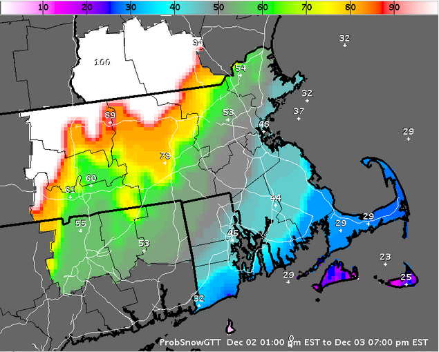

Probability of Snow, Evening of 12/2/2014
— Potentially Hazardous Winter Weather This Evening —
Shrewsbury Area Weather for Today, 12/02/2014 (see disclaimer at bottom)…
1300 12/02 fcst
Today Dew Point ~25°F, High T ~34°F, Low T ~32°F, WindsENE – E @ 5 MPH
Precip: Rain/Mixed Precip after ~6:30 PM
Details:
A warm front is moving through our area and will bring light snow to our north and west, and a mix of rain, sleet and freezing rain to our area later this evening overnight into tomorrow AM. Precip will transition over to all rain early tomorrow morning…
Travel this evening is expected to be slippery at times, especially on secondary roadways. Slick conditions may persist into tomorrow morning’s commute. Caution is advised when driving tonight and tomorrow morning – leave some extra time for your travels…
Last storm:
I forecasted total snow accumulation between ~4.5″ to ~6.8″ , and the official measured (by NWS) snow total for Shrewsbury was 6.2″. The timing for onset, changeover to mixed precip and back again, as well as when the storm ended played out according to my forecast. The coastal front didn’t penetrate inland quite as far as I anticipated, which allowed for a bit less freezing rain and a bit more sleet that pushed accumulations towards the upper end of the range.
Disclaimer:
My forecasts should not be used for anything other than general information.
You should not send my forecasts to others without this disclaimer attached
so that there is no chance of misinterpretation by others. Thanks!
Steve
______________________________
– Civilization exists by geological consent, subject to change without notice. -
