Prob of Snow

Prob of Snow

Probability of Snow, Evening of 12/2/2014

— Potentially Hazardous Winter Weather This Evening —
Shrewsbury Area Weather for Today, 12​/02​/2014 (see disclaimer at bottom)…
1300 12/02 fcst

Today Dew Point ~2​5​°F, High T ~3​4​°F, Low T ~32°F, Winds​E​N​E – E​ @​ 5​ MPH

Precip: Rain/Mixed Precip ​after ​~​6​:30 P​M

​ ​
Details:
​A warm front is moving through our area and will bring light snow to our north and west, and a mix of rain, sleet and freezing rain to our area later this evening overnight into tomorrow AM.  Precip will transition over to all rain early tomorrow morning…
​Travel this evening is expected to be slippery at times, especially on secondary roadways.  Slick conditions may persist into tomorrow morning’s commute.  Caution is advised when driving tonight and tomorrow morning – leave some extra time for your travels…
Last storm:
I forecasted ​total​ s​now ​accumulation​ between ~4.5″ to ~6.8″ ​, and the official measured (by NWS) snow total for Shrewsbury was 6.2″​.  The timing for onset, changeover to mixed precip and back again, as well as when the storm ended played out according to my forecast.  The coastal front didn’t penetrate inland quite as far as I anticipated, which allowed for a bit less freezing rain and a bit more sleet that pushed accumulations towards the upper end of the range.
Disclaimer:

My forecasts should not be used for anything other than general information.
You should not send my forecasts to others without this disclaimer attached
so that there is no chance of misinterpretation by others.  Thanks!

Steve
_________________________________________________________________

– Civilization exists by geological consent, subject to change without notice. -​

ThanksgivingNorEaster2914

Final for this Storm:

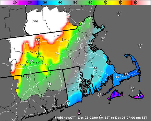
Shrewsbury received 6.2″ of snow/IP

Steve

ThanksgivingNorEaster2914

Bullseye for Shrewsbury, MA

— Winter Storm Warning in effect until 7 AM Tomorrow —

Shrewsbury Area Weather for Today, 11/26/2014 (see disclaimer at bottom)…
0700 11/25 fcst

Today (Wednesday)
Dew Point ~29°F, High T ~39°F, Low T ~30°F, Winds N @ 4 – 10 MPH Gusting to ~20 MPH
Precip: Rain/Mixed Precip ~8:00 AM; Heavy Snow ~10 AM to ~3PM; Mixed Precip ~3PM to ~8PM; Snow ~8PM to 3AM

Tomorrow (Thanksgiving)
Dew Point ~26°F, High T ~34°F, Low T ~25°F, Winds N – WNW @ 2 – 10 MPH Gusting to ~20 MPH
Precip: Chance of flurries throughout the day

Total Snow Accumulation: ~4.5″ to ~6.8″, higher totals at higher elevations (up to ~10″ possible)

Details:
As you can see, I have decreased the total totals for snow accumulation, however this precip profile is actually worse for travel…

Precip will arrive a bit later than originally anticipated a couple of days ago, and will be a rain/mix. We will have a very abrupt changeover to snow with heavy snowfall rates mid-morning. This is because the precip will entrain cold air from aloft and pull it right down to ground level. (In other words, the precip will be falling uninterrupted as it changes from rain to snow – expect roads to be difficult when the changeover takes place.) Snow will continue until the coastal front moves in from the west and crosses/stalls over our area and delvers a mix of sleet/ice pellets and freezing rain. Later in the evening, the coastal front will recede back towards Boston and we will finish up as snow.

SO, the storm track as moved west which give us a warmer solution. There was an indication last night from one model that suggest the warm air intrusion from the coastal front, and all the models picked up on it earlier this morning. So, we are in for a very messy early-season Nor’ Easter.

Numerous cancellations and early closures have already been announced, so plan accordingly. Be especially careful driving on secondary roads as the transition to snow will be abrupt and will result in slick driving conditions.

I will send another update this afternoon.

Happy Thanksgiving!

Steve
On Tue, Nov 25, 2014 at 8:27 PM, Stephen Daukas wrote:
— Winter Storm Warning in effect from 7 AM Tomorrow to 10 AM Thursday —

Shrewsbury Area Weather for 11/26/2014 (see disclaimer at bottom)…
2000 11/25 fcst

We are on track in terms of the Nor’Easter hitting the benchmark, but I am revising my QPF downward by a bit taking into account the shift in timing for the storm as well as a slower-than expected traverse of the cold front from the Great Lakes…

Total Snow Accumulation: ~5.6″ to ~7.0″ with higher amounts at higher elevations to our west.

Considering the warm air aloft in the middle atmosphere overnight, and the recent warm ground temps, I expect accumulations to begin ~9 AM with much less accumulation on paved surfaces. Secondary roads will experience accumulating snow starting ~Noon, with primary roads (highways) remaining mostly wet until ~2 PM…

Otherwise, the storm is basically on track… Heavy snow for tomorrow with basically a ~6″ son storm, followed by clear and cold conditions on Thanksgiving day.

Next update tomorrow morning.

Steve
On Tue, Nov 25, 2014 at 12:45 PM, Stephen Daukas wrote:
— Winter Storm Warning in effect 7 AM Wednesday to 10 AM Thursday —
— High Wind Watch for East Coast, Cape & Islands —

Shrewsbury Area Weather for 11/26/2014 (see disclaimer at bottom)…
1300 11/25 fcst

Tomorrow (Wednesday)
Dew Point ~29°F, High T ~35°F, Low T ~29°F, Winds W – N @ 3 – 7 MPH Gusting to ~20 MPH
Precip: Rain/Mixed Precip ~9 AM, Heavy Snow ~10 AM ending ~Midnight

Thursday (Thanksgiving)
Dew Point ~26°F, High T ~33°F, Low T ~25°F, Winds N – WNW @ 2 – 6 MPH Gusting to ~20 MPH
Precip: Snow Showers/Flurries early

Total Snow Accumulation: ~6.6″ to ~8.4″ with higher amounts possible and isolated areas of ~12″ possible

Details:
You can disregard my last update, it was based on bad data that essentially flipped the storm… So, rather than run everything remotely, I am at home in the DWC for lunch validating my forecast…

The above forecast is the correct forecast. There is a slight shift in timing to a later solution with rain transitioning to snow ~9:30 AM, followed by heavy snow. Otherwise, nothing else has changed…

I will send an updated forecast this evening…

Steve

On Tue, Nov 25, 2014 at 8:52 AM, Stephen Daukas wrote:
— Winter Storm Warning in effect from 7 AM Wednesday to 10 AM Thursday —

Shrewsbury Area Weather for 11/26/2014 (see disclaimer at bottom)…
0700 11/25 fcst

Tomorrow (Wednesday)
Dew Point ~29°F, High T ~35°F, Low T ~29°F, Winds W – N @ 3 – 7 MPH Gusting to ~20 MPH
Precip: Heavy Snow ~8 AM ending ~11 PM

Thursday (Thanksgiving)
Dew Point ~26°F, High T ~33°F, Low T ~25°F, Winds N – WNW @ 2 – 6 MPH Gusting to ~20 MPH
Precip: Snow Showers/Flurries linger until ~12 Noon

Total Snow Accumulation: ~6.6″ to ~8.4″ with higher amounts possible and isolated areas of ~12″ possible

Details:
Colder air will move into our area this afternoon and a coastal Low will develop off the Carolinas setting the stage for a Nor’ Easter tomorrow. The central Low of this system looks to make a direct hit on the 40/70 benchmark, which translates into plenty of snow for the greater Shrewsbury area…

I expect we will start off with some light rain/mixed precip ~4AM from the northernmost shield of the storm as it approaches from the south. Precip will changeover to light snow ~6AM. Then, the main event will take place with snow rapidly increasing after ~8 AM approaching rates of ~1″ per hour… Mesoscale snow banding is expected… Areas affected by banding will see snowfall rates approaching 2″ per hour with higher snow accumulations topping out at ~12″… Those ~12″ totals are more likely at higher elevations where banding occurs…

Winds will become backing from the NW which will setup a coastal front… Snow totals will fall off rapidly east of the Rt 128 corridor. A low-level jet streak will cross over RI and Cape Cod bringing winds in the vicinity of ~60 MPH to that general area during tomorrow afternoon into the late evening.

Expect a major impact to Thanksgiving travel plans. For those travelling by car, you should plan to arrive at your destination in this area by ~6 AM. Travel after that time becomes risky because of the rapid increase in snowfall rates. Travel after ~8 AM is not advised!

Expect numerous delays and cancellations tomorrow!

All in all, our first winter storm comes in earlier than is typical. While the details of the forecast are likely to change a bit over the next 12 hours, plan on a sizeable winter storm tomorrow and a white Thanksgiving!

I will send another update this evening…

Steve

On Mon, Nov 24, 2014 at 9:32 PM, Stephen Daukas wrote:
— Winter Storm Watch in effect from Wednesday morning through Thursday morning —

Shrewsbury Area Weather for 11/26/2014 (see disclaimer at bottom)…
2000 11/24 fcst

I am updating my forecast and taking a close look at the models as we speak…

I wanted to give everyone a heads-up that it looks like the central Low may will hit the 40/70 benchmark and we could well be looking at a Nor Easter with accumulations between ~6″ and ~12″ of snow on Wednesday, running from ~8 AM to ~8 PM, with lingering light snow into Thanksgiving…

I will be sending a full forecast tomorrow morning, and lets hope the storm track changes between now and then!

Steve

On Mon, Nov 24, 2014 at 8:59 AM, Stephen Daukas wrote:
— Winter Storm Watch in effect from Wednesday morning through Thursday morning —

Shrewsbury Area Weather for 11/26/2014 (see disclaimer at bottom)…
0600 11/24 fcst

Tomorrow (Tuesday)
Dew Point ~54°F down to 29°F, High T ~56°F, Low T ~37°F, Winds SW – W @ 3 – 10 MPH
Precip: None

Wednesday (Wednesday)
Dew Point ~29°F, High T ~35°F, Low T ~32°F, Winds W – NNE @ 3 – 10 MPH
Precip: Snow Possible…

Total Snow Accumulation: ~3″ to ~10″ (PRELIMINARY)

Thursday (Thanksgiving)
Dew Point ~27°F, High T ~35°F, Low T ~28°F, Winds NNE – W @ 3 – 7 MPH
Precip: Snow Showers/Flurries linger through the AM…
Details:
Models are having a hard time arriving at consensus on this storm’s track and, as we know, storm track determines temp profiles up though the atmosphere, which impacts how much precip as well as the type of precipitation, etc., etc. What follows is a best-guess based on available data as of early this morning…

Right now, the East-West extent of the storm track ranges from well to the East of Cape Cod and Nantucket to inland over Pennsylvania. This variance, as you might guess, brings in entirely different forecasts depending on where the track settles. Looks like we have a 70% probability of the main axis of precip from Shrewsbury to Hartford. However, the possible area of storm track does include the storm hitting the 40-70 benchmark (~100 miles off Nantucket), which would translate into a pretty big storm for our area.

My current QPF places us anywhere from ~3″ of snow to more than ~12″, although I do believe we will be closer to ~3″. Also, ground temps have remained warm so the amount of snow that falls does not equate to accumulation on the ground. It looks likely that areas west of I-95 will see mostly snow with most of the accumulation (possibly approaching ~6″) over the Worcester Hills and into northern CT. The timing of the storm looks to be between 10 Am and 8 PM, with lingering light snow into Thanksgiving morning.

Again, this is by no means a solid forecast. I’m anticipating higher confidence in my forecasts later tonight and tomorrow.

Bottom line: Prepare for a typical early-winter snow event. Get your shovels and snow blowers ready, top-off your windshield washer fluid and gas tanks, and try to travel on Tuesday to avoid whatever comes our way.

I will send an update forecast later today.

Disclaimer:
My forecasts should not be used for anything other than general information.
You should not send my forecasts to others without this disclaimer attached
so that there is no chance of misinterpretation by others. Thanks!

Steve
_____________________________________________________________
– Civilization exists by geological consent, subject to change without notice. –

View from Mt Willey

View from Mt Willey

View from Mt Willey

Our first climb of 2014 turned out to be one of the best climbing days we have had in a long time!

We started at the Ethan Pond Trailhead near Ripley Falls, and then ascended Mt. Willey. Within the first 5 minutes, we had to pull out the maps – the Ethan Pond Trailhead isn’t that obvious…  After taking the only trail up from the parking area, and crossing an active railroad track, we came across this sign…

Ethan Pond Trail / Ripley

Ethan Pond Trail / Ripley

We figured this was the right trail because Ripley Pond Trail breaks off of Ethan Pond, which is the one we needed to follow in order to get to the Willey Range Trail.  Sure enough, we came across the trail junction denoting the trail we wanted!

As we climbed upward, we enjoyed some very moderate grades, and then the trail steepened.  After ~1 hr of a collection of steep sections on the trail, we hit “the ladders.”  This last steep section to Mt Willey summit is overcome by ladders – wooden steps cut out of tree trunks – that get steeper and approach near vertical the higher one climbs, which made it fun for the two dogs (we had to carry each up the steepest section).

This pic doesn’t show the steepest ladder, and we weren’t about to stop and try to take a picture as we were already tense enough just making our way up!  One slip could have resulted in a 20′ or 30′ fall.  So, heads down as we climbed the ladders…

Willey Ladders

Willey Ladders

After the ladders, and a couple of rocky sections, we reached the summit.  Total time to the summit of Mt. Willey was ~3 hours.  Once at the summit, we took a ~30 minute break to take pics, eat our traditional PB&J sandwiches, fruit, cheese, etc., etc.

View from Mt Willey

View from Mt Willey

After our rest, we crossed over Mt Willey summit and continued to Mt. Field, which took ~1 hour…

Once we reached Mt Field, we had some nice views into the valley where we could see the Mt Washington Inn (picture below as the red/white spec in the center of the picture).

View From Mt Field

View From Mt Field

After another ~30 minute break, we continued on to Mt. Tom.

As we continued, we began descending into the col between Mt Field and Mt Tom, which was far steeper and deeper than we had anticipated.  The descent was roughly equivalent to a 56 story office building, and then we had to go back up.

At one point, we ran into a couple of hikers who had started back up the trail thinking they had somehow made a mistake and taken the wrong path.  I explained to them that the other trail option back at the previous summit was the Avalon Trail that did not take them to Mt Tom, and assured them they were on the right path, steep as it may be…

Eventually, we made our way down to the next trail junction where we took the Mt Tom Spur to the summit of Mt Tom (funny how that works).

View From Mt Tom

View From Mt Tom

View From Mt Tom

View From Mt Tom

After another short break, we took the Mt Tom Spur trail back down to the trail junction, and then took the Avalon Trail back to the AMC Highland Center / Train Depot.  The descent took ~1.5 hours.

When Paul and Karen got down to the Crawford Notch Depot next to the AMC Highland Center where we parked the first of our two vehicles, they noticed a large group was having a cookout…  Karen hung out at the Depot while Paul came back up the trail to meet Christine and me (we two who had been taking our time on the descent looking at the geology, interesting gnarled trees, fungi, flowers, and so on) to let us know they had run the dogs down to the Depot and there was a cookout going on…

Crawford Notch Depot

Crawford Notch Depot

Once were were all at the Depot, Karen and Christine walked over to the Highland Center while Paul and I drove back to the starting trailhead to pick up the other vehicle.

AMC Highland Center

AMC Highland Center

Paul and I joined Karen and Christine at the Highland Center for a short break, browsed the various AMC merchandise, sat on the comfy couches (think yellowstone lodge) before heading back to the cottage (Squam Lake) for a shower, change of clothes, advil, and chicken burgers for dinner.  Of course, we had ice cream with maple syrup for dessert!


WilleyFieldTom

Mt Willey, Mt Field, and Mt Tom

Mt Willey, Mt Field, and Mt Tom

Depending on weather, we are planning three peaks for our first expedition of the year – Mt Willey, Mt. Field, and Mt. Tom.

Starting at the Ethan Pond Trailhead, we will climb to Mt. Willey, continue over the summit to Mt. Field, and then take Mt. Tom before heading out using the Avalon Trail.  If all goes as planned, this will be an 8.55 mile excursion taking about 6 hours or so.

We will end at the AMC Highland Center where, perhaps, we can stop for a rest and some hot food.  Then again, we tend to head back to the cottage (Squam Lake) for a show and change of clothes before heading to The Common Man restaurant  for some awesome food.  We have taken to eating our dinners up in the loft while sitting on the comfy couches.

Old New England Houses

From Yankee Magazine, by Mark Brewer

Congratulations! As the proud new owner of a vintage New England home, you can look forward to many years of satisfaction, enjoyment, and repairs.

Steep Thrills
Note the daring slope of the roof, which has approximately the same pitch as Tuckerman Ravine and will get you to the bottom just as fast in case of emergency. A built-in snow-removal system uses heat from the house to melt the white stuff and transform it into those charming full-length icicles featured on New England calendars. (See Appendix B: “Ice Dams.”)

Boxed In
The attic of your old house comes pre-filled with ancient furniture, clothes, and trunks. Don’t worry, none of it’s valuable–your junk will fit right in! The attic is climate-controlled to be an oven in summer and a freezer in winter, just as nature intended.

Rooms with a Flue
Your brick chimney was designed to let small animals come and go at their leisure, providing you with many happy evenings playing “What’s That Noise?”

Breezy Does It
You’ll enjoy fresh air year-round, thanks to patented Flo-Thru technology, consisting of hundreds of tiny air leaks strategically placed around windows, doors, and other openings. Many of these gaps are large enough to let insects pass through, bringing the wonder of nature right into your home.

Hidden Turn-Ons
Light switches in new houses are generally placed just inside entry doors–boring! You’ll find your light switches outside the door, down the hall, and possibly in your neighbor’s broom closet.

Privy Counsel
You’ll enjoy the luxury of 1-1/4 baths (the downstairs toilet was originally an ironing-board closet). The main bath features a clawfoot tub that your friends will ooh and aah over but will not take off your hands, as it weighs only slightly less than the Hoover Dam. There’s no shower, but you can easily add one using a variety of contraptions, most of which will also add a refreshing moistness to the walls and floors.

Wall or Nothing
The walls of your home have been filled with old newspapers that provide an insulating R-value of 0.0002, largely owing to the use of words like “coruscate” and “perspicuous” in the text. The surface is genuine horsehair plaster, noted for its attractiveness, durability, and tendency to crumble to pieces if you try to hammer a picture hanger into it.

Floor Better or Worse
Luxuriate in the warmth and beauty of genuine hardwood floors. They’re guaranteed to be maintenance-free, as long as you don’t care what they look like. They also act as built-in hygrometers, alerting you to excess humidity by popping up high enough to stub a toe on.

Cellar Beware
Your New England cellar is a haven of dampness, coolness, and mold spores the size of rutabagas. Unlike modern basements with their tediously straight angles and smooth walls, your cellar incorporates features of its natural surroundings, such as boulders, ledges, and major root systems. In places, the cellar is actually large enough to let you stand up straight, though generally not where you need to access wires or pipes for repairs. Here, you’ll find handy crawl spaces, home to a variety of interesting creatures, including spiders resembling mohair work gloves. After a long winter, the sound of running water will alert you to the arrival of spring as it passes through your cellar.

The Heat Goes On … and On … and On
Your old house comes equipped with an original furnace the size of a Winnebago. This classic heap o’ technology fires up with a house-rattling roar just a few decibels shy of a space-shuttle launch, giving you the calm assurance that it’s working day and night. Heat is delivered through a single vent to the living room, where it’s free to roam the rest of the house, though it rarely feels called upon to do so. In later models, heat may be provided via iron radiators, which can also be used as anchors by any Class 2 cargo ship.

1-18StormTotalSnow

Well, as I note below, my first forecast back on the 17th was for not much of a storm for our area, and that turned out to be true.  In the intervening days, the short-range models suggested the storm would be able to press farther into the arctic air mass.  And, as we can see from the graphic above, that didn’t happen.

— Winter Storm Warning is Cancelled —
— Wind Chill Advisory in Effect until 10 AM Today —

Summary for Shrewsbury Area, 1/21-22/2014 (see disclaimer at bottom)…

1700 1/21 fcst

Storm Total: 2.3″ snow.

Details:
I woke this morning to my lovely bride saying “Lucy, you’ve got some ‘splaining to do!”  I should have stuck with my synoptic forecast of the 17th when I said the arctic front would protect us from this storm!  The arctic air mass, along with persistent winds from the north, kept the storm shield from pushing into our area.  The cutoff of the northern shield of the storm was very sharp – Leominster received 0.8″, Worcester 1.8″, Shrewsbury and Westborough 2.3″, Milford got over 6″.  According to the DWC Mobile Unit, driving this morning in ~2″ of snow was very difficult in Worcester (as it typical), and Worcester schools have a 2-hour delay.  Shrewsbury and other local schools are open per usual.

Just keep in mind that the Cape and south coastal areas are still under a blizzard warning.  Snow totals being reported to NWS Taunton for this area are in excess of 16″ and it is still accumulating.  Driving in this area should be avoided if at all possible.

Also, be cautious outside today.  Temps are frigid and winds will contribute to wind chills well below zero.

Steve

On Tue, Jan 21, 2014 at 5:32 PM, Stephen Daukas wrote:

— Winter Storm Warning in Effect from 1 PM Today to 1 PM Tomorrow —
— Wind Chill Advisory in Effect from 10 PM Tonight to 10 AM Tomorrow —

Shrewsbury Area Weather for Today/Tomorrow, 1/21-22/2014 (see disclaimer at bottom)…
1700 1/21 fcst

Total precip: ~6.4″ to ~8.1″ of snow by Wednesday PM.

Details:
Forecast snow totals are unchanged.  In my last update, I said I was leaning towards the higher end of the forecast range and this time I’m leaning towards the lower end…  That is usually a sign that the forecast has settled down…  Also, timing of the end of precip has shifted a bit earlier to ~11:30 AM, although the warnings are set to expire at 1 PM.

My last update called for Virga to changeover to snow at ~3:15 PM and it started snowing at 3:19 PM in Shrewsbury (I just happened to be outside when the snow began).  Not bad, but that made me think of the Heisenberg Uncertainty Principle! 😉

Cancellations are starting to pile up as anticipated.  (You know its going to be a bad snow storm when Our Lady of Hope closes!)

Again, if you have to travel, check local weather outlets and monitor news forecasts before heading out on the roads.

Next update either later tonight or tomorrow AM.

Steve

On Tue, Jan 21, 2014 at 1:02 PM, Stephen Daukas wrote:

— Winter Storm Warning in Effect from 1 PM Today to 1 PM Tomorrow —
— Wind Chill Advisory in Effect from 10 PM Tonight to 10 AM Tomorrow —

Shrewsbury Area Weather for Today/Tomorrow, 1/21-22/2014 (see disclaimer at bottom)…
1230 1/21 fcst

Timing is a bit slower for our area with snow reaching the ground ~3:15 PM (although it is already snowing over south coastal zones, which is earlier than expected).  The start of the evening commute will not be as difficult as anticipated, but the heavier snow should arrive ~6 PM.  Still on track for the remainder of the forecast below.

Next update will be early this evening.

Steve

On Tue, Jan 21, 2014 at 8:01 AM, Stephen Daukas wrote:

— Winter Storm Warning in Effect from 1 PM Today to 1 PM Tomorrow —
— Wind Chill Advisory in Effect from 10 PM Tonight to 10 AM Tomorrow —

Shrewsbury Area Weather for Today/Tomorrow, 1/21-22/2014 (see disclaimer at bottom)…
0600 1/21 fcst

Total precip: ~6.4″ to ~8.1″ of snow by Wednesday PM.

Details:
We now have a nice setup for snow:  cold temps and a strengthening Low near to the 40/70 benchmark south of Nantucket.  The track of the storm has shifted a bit such that we will be getting more snow than what was forecast yesterday…  The Cape will likely see blizzard conditions (and is under a blizzard warning).  QPF actually hasn’t increased all that much, but I have increased my forecast snow totals by ~1.5″ (and am leaning towards the higher end of the forecast range) due to the very cold temps (higher snow ratio) and the storm track shift towards the benchmark.

More technically, the Low will move along the stalled arctic front along the mid-Atlantic as a consequence of a very strong short wave moving out of the Ohio valley.  The timing of the snow is still as described in my earlier forecast, with snowfall beginning early afternoon and increasing snowfall rates by ~6 PM as the Low approaches the benchmark.  Strong pressure falls associated with the Low will allow for banding (periods of very heavy snowfall and limited visibility) and high winds gusting to 30 MPH for our area, higher snowfall and winds to our south.

Today’s evening commute and tomorrow morning’s commute will be difficult.  Expect some cancellations this afternoon and numerous closings and cancellations tomorrow.  Again, keep in mind that frigid temps allow for snow to instantaneously adhere to surfaces, and treated surfaces will still be slick.  If you must drive during this storm, be extra cautious.  This storm will develop fairly quickly as it picks up moisture from the Atlantic, and it could deepen more than currently expected.

You should continue to monitor local media outlets for updates and additional warnings during the day today, and be prepared for a difficult evening commute.  Tune your NOAA All Hazards Wx Radio (that you all have, of course) to Channel 7 for the Worcester area for any late-breaking changes…

I will send updates as the storm develops.

On Mon, Jan 20, 2014 at 5:36 PM, Stephen Daukas wrote:

— Winter Storm Warning in Effect from 1 PM tomorrow to 1 PM Wednesday —

Shrewsbury Area Weather for Tuesday/Wednesday, 1/21-22/2014 (see disclaimer at bottom)…
1700 1/20 fcst

Tomorrow
Dew Point ~1°F, High T ~17°F, Low T ~9°F, Winds NNW – NNE @ 6 – 14 MPH
Precip: PM Snow 

Wednesday
Dew Point ~-4°F, High T ~13°F, Low T ~2°F, Winds N – WNW @ 9 – 15 MPH
Precip:  AM Snow

Total precip: ~5.8″ to ~6.4″ of snow by Wednesday PM.

Details:
The arctic air mass that looked like it would hold this storm far enough out to sea such that we would be spared, isn’t quite doing what I hoped…  The ocean-forming storm will, in fact, be SE of the 40/70 benchmark, but still close enough for us to get a good portion of the snow that will be concentrated over Cape Cod.

The QPF (quantitative precipitation forecast) for this storm is as much as 0.8″ (liquid equivalent) over the Cape.  Because of the arctic air mass emplaced over the region, the usual snowfall to liquid ratio of 10:1 is out the window.  Ratios would be closer to 15:1 or even as high as 20:1.  This cold cold air actually makes it a bit harder to discern the depth of snow that will accumulate on the ground.  My math comes out to between ~5.8″ and ~6.4″ of snow.  Areas to our south and east could easily see ~12″ plus from this storm.

Timing looks like snow will begin ~11 AM as Virga, with snow making all the way to the ground ~12:30 PM once the air column is saturated.  And, of course, the evening commute will be snowy and difficult.  The Wednesday AM commute will be especially difficult with snowfall rates of ~0.4″ per hour, which is not anything you want to drive in if you can avoid it.  Also, keep in mind, that the normal salts used for treating road surfaces do not work very well with temps in the single digits and low teens…    Some snow crews will add calcium chloride to the mix, but most will be using the standard sodium/sand mix.  Bottom line is that treated roads will still be slick.

You should monitor local media outlets for updates and additional warnings during the morning tomorrow, and be prepared for a long, difficult evening commute.  Tune your NOAA All Hazards Wx Radio (that you all have, of course) to Channel 7 for any late-breaking changes…

I will be running the numbers tonight and again tomorrow morning and will send an update tomorrow morning.

Last storm was “one of those…”  I originally was looking at a “coating to ~1” type of event.  I then went into a long meeting and when I got a chance to have a look at what was going on a few hours later, I knew then that we were experiencing something called “entrainment.”  That is when precip falls rapidly enough to pull cold air down from aloft, which turns everything to snow.  It is also something of a self-reinforcing phenomena resulting in more precip that usual…  Shrewsbury was on the apex of one zone that widened to our north east.  The second zone was well to our south west.  My update was ~4.7″ of snow, and we ended up with 5.5″ (official final from NWS).  Some areas of Shrewsbury closer to Boylston got more snow (Boylston had ~8″ and Westborough had ~6.5″.  Milford had ~3″ and Brookfield had ~1″).

Disclaimer:
My forecasts should not be used for anything other than general information.
You should not send my forecasts to others without this disclaimer attached
so that there is no chance of misinterpretation by others.  Thanks!

Steve
_________________________________________________________________
– Civilization exists by geological consent, subject to change without notice. –

View from Mt Jackson

View from Mt. Jackson

View from Mt. Jackson

With the move to our new home and all the packing and unpacking that goes along with it, we were only able to climb three more mountains this year: Mt. Waumbeck, Mt. Cabot, and Mt, Jackson.  We are now ¼ through the 48 4,000 foot peaks of the NH White Mountains.

We are working out through the winter so that we will be able to blaze through the rest of the 5,000 footers and some of the higher 4,000 footers this summer.  We are looking forward to climbing with both Grady and Chester!